
At a glance
| Mill Dam built | Authorized 1814, completed 1821 |
|---|---|
| Filling began | Fall of 1857, with fill brought by rail from Needham |
| Street plan | Arthur Gilman, submitted November 5, 1856 |
| Original buildings | 1,156 on the originally vacant residential lots |
| Architectural District | Created 1966; expanded 1974, 1979, 1981 |
| National Register | Listed 1973 |
Why is it called Back Bay?
The neighborhood is named for the water it replaced. Back Bay Houses describes the site as originally a relatively shallow bay and tide lands on the Charles River, and the name stayed after the bay was filled. In 1814 the state legislature authorized the Boston and Roxbury Mill Corporation to build the Mill Dam from the corner of Charles and Beacon Streets west to Sewall's Point, today's Kenmore Square. It cut off about 430 acres of tidal land from the river.
A Cross Dam split the enclosed water into a western Full Basin, roughly where the Fenway is now, and an eastern Receiving Basin, roughly where Back Bay is now. Tides filled one basin and drained through the other to drive mills. A toll road on top of the Mill Dam became the western extension of Beacon Street. The project was finished in 1821 and was not a success: two railroad causeways built across the Receiving Basin after 1834 cut the tidal flow, sewage drained into the basins, and the area became foul just as Boston needed land for a growing population.
Filling the Back Bay, 1857 to the 1880s
Three owners held the flats: the Commonwealth of Massachusetts, the Boston and Roxbury Mill Corporation (the land north of the Mill Dam, now the north side of Beacon Street) and the Boston Water Power Company (the central and southern parts). Agreements in 1854 and 1856 settled ownership and set the rules. Land for streets was to be filled to the height of the Mill Dam, and building lots to five feet below it, so that house cellars would not need digging.
Filling south of the Mill Dam began in the fall of 1857. Contractors Norman C. Munson and George Goss brought fill by railroad from Needham. The work moved roughly east to west, and the blocks north of Commonwealth Avenue filled faster than those to the south. By 1881 the fill had reached Massachusetts Avenue, then called West Chester Park, and the last blocks to the west were filled in the early 1880s along with the new park at the Back Bay Fens.
Lots were sold while the filling went on, often before a block was finished, and the Commonwealth sold its land at public auction. The City of Boston sums up the result as over 450 acres of usable land by the 1880s.
Arthur Gilman's 1856 plan and the alphabetical streets
Architect Arthur Gilman submitted a plan to the legislature's joint committee on November 5, 1856. A newspaper of the time credited him with originating its main features, and the committee also credited George Snell and the landscape gardeners Copeland and Cleveland. Gilman had travelled to Paris to study its rebuilding, and the National Park Service links his design to American interest in French planning.
The plan laid five streets east to west: Beacon, Marlborough, Commonwealth, Newbury and Boylston. Eight north-south streets cross them in alphabetical order: Arlington, Berkeley, Clarendon, Dartmouth, Exeter, Fairfield, Gloucester and Hereford. Beacon was planned 70 feet wide, Marlborough and Newbury Street 60 feet, and Commonwealth Avenue was widened from a planned 120 feet to 200 feet, with a 100-foot central mall. West of Massachusetts Avenue, Commonwealth bends northwest to run parallel to the old Boston and Albany Railroad tracks.
Deed restrictions shaped the houses as much as the plan did. The Commonwealth's deeds required buildings of at least three stories in brick, stone or other non-combustible material, banned stables and manufacturing, and set front setbacks of 20 to 25 feet depending on the street. A 16-foot alley ran behind the lots so that deliveries stayed off the main streets. The guide to Back Bay's streets shows how these rules still define each block.
Building eras in the residential Back Bay
Back Bay Houses counts 1,156 buildings constructed on the originally vacant lots of the residential district: Beacon, Marlborough and Commonwealth and the cross streets north of Newbury. That is not a count of every building in the wider neighborhood. Construction moved from east to west as the land was filled.
1856 to 1859: the first houses on Beacon Street
The first Back Bay houses went up on the north side of Beacon Street between Arlington and Berkeley, on land behind the Mill Dam that had been filled by 1851. Most were built in 1856, with two completed in 1857.
1860 to 1864: building on the new fill
The first houses on newly filled land south of the Mill Dam rose in the early 1860s; Back Bay Houses records 154 buildings in these five years. Gilman's Arlington Street Church, built in 1860-1861, was one of the first two churches in the neighborhood.
1870 to 1874: the boom and the bust
242 buildings went up, 207 of them in 1870-1872. Construction then fell sharply after the Great Boston Fire of November 9, 1872 and the Panic of 1873. The Commonwealth suspended sales of its Back Bay land in March 1872 and did not resume until May 1879.
1880 to 1884: west of Massachusetts Avenue
With the last blocks filled, building reached Charlesgate East; 198 buildings went up in these five years. The first houses west of Massachusetts Avenue were on Commonwealth Avenue.
1890 to 1899: apartment houses and hotels
The 1890s brought large apartment houses and apartment hotels, mostly on Commonwealth Avenue and at the western end; 89 buildings were built. Back Bay Houses notes that before the 1890s the houses were largely winter residences, and these buildings made apartment living more attractive.
1900 to 1909: the last original lots
By 1900 almost every original lot was built on. Only 21 buildings went up in this decade, and the last single-family house on an originally vacant lot was finished in 1908.
1910 onward: replacements and multiple dwellings
After 1910, new construction focused on apartment buildings. As of 2015, 99 original buildings had been demolished and replaced by 61 newer ones; the last original buildings came down in 1967, on Marlborough Street.
Architectural styles and the brick or brownstone question
Changing tastes, east to west
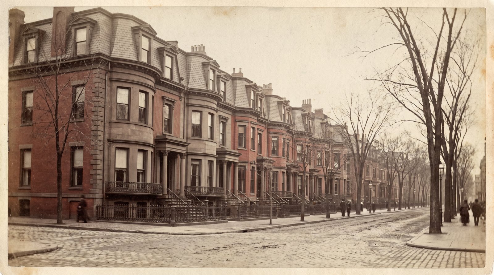
The City describes Back Bay as illustrating the changing tastes of American architecture from the mid-19th to the early 20th century. A City historic-districts official summed up the sequence this way: early buildings often used brownstone and were quite French, later ones drew on London, and by the 1890s Boston was exploring colonial and federal styles and materials. The Architectural Commission's own paint guidance separates dark and light masonry buildings and mentions Colonial Revival buildings, which shows how mixed the district is. How these rowhouses compare with Beacon Hill and the South End is set out in Boston's brownstone neighborhoods compared.
Brick, brownstone or both
The Gibson House on Beacon Street, now a museum, is a typical early house: brownstone at the basement and first floor, red brick with brownstone trim above, and a mansard roof. The National Park Service calls it an early example of the French Second Empire style. Many Back Bay houses are red brick with brownstone trim, and no published source gives the share that are faced in brownstone. On this site, brownstone means the neighborhood's 19th-century rowhouses in the everyday sense; the explanation of what a brownstone is covers the stone itself.
Where the stone came from
The stone came from quarries at Portland, Connecticut, shipped by schooner. Its popularity grew through the mid-1800s and peaked in the early 1890s. It weathers badly when water and salt get into its layers, which is why so many fronts have been patched or rebuilt.
From single-family houses to apartments and condos
Most Back Bay buildings were built as single-family houses. Largely after World War I, many became lodging houses, dormitories, fraternities, apartments, schools or medical offices. Boston's first conversion of an existing residential building into condominiums took place in Back Bay, in a Gloucester Street building, in November 1969.
Back Bay Houses calls condominium conversion probably the single most important innovation that kept the old buildings in use as homes, and says it saved many from demolition. Many of the old houses now hold several condo units, and some have been converted back into single-family homes; no count of those is published. The guide to whole Back Bay townhouses covers the houses still in single ownership.
Back Bay in the 20th century
The Charles River Dam and the Esplanade
The river edge changed after the houses were built. The Charles River Dam was completed in 1910, and the Charles River Esplanade was built along the Boston bank afterward, behind the houses on the river side of Beacon Street. It remains the neighborhood's riverfront park.
Towers along the southern edge
The tall buildings came later and stayed at the edges. In the 1960s Boston's High Spine plan steered high-rise construction toward the corridor of the Massachusetts Turnpike, along Back Bay's southern side. The 52-story Prudential Tower was finished in 1964, and I. M. Pei's firm designed the 60-story John Hancock Tower, the tallest building in New England when it was built. The Colonnade Hotel followed in 1971. Those towers, not the rowhouses, are why the Prudential Center's ZIP shows tower-condo values; the ZIP code breakdown for Back Bay separates the two. The residential blocks to the north kept their 19th-century scale under the Architectural District, described below.
The Architectural District and National Register
The legislature created the Back Bay Architectural District and its Commission in 1966 (Chapter 625 of the Acts of 1966), and the district was expanded in 1974, 1979 and 1981. It was the second of Boston's nine city-designated historic districts. Back Bay was listed on the National Register of Historic Places in 1973. Since 1966, all proposed exterior work in the district has needed the Commission's approval, and demolition of historic buildings in the residential area is prohibited. For what the protected streets are like to live on now, see daily life in the Back Bay neighborhood.
Wood piles and groundwater
Every original building rests on wooden piles driven through the fill. Back Bay Houses notes that the original piles still carry the foundations, and they stay sound only while groundwater covers them; if the water drops and the piles dry out, they rot and foundations fail. The Boston City Council created the Boston Groundwater Trust in 1986 to monitor groundwater in neighborhoods built this way. For the checks an owner or buyer can make today, see piles, groundwater and approvals for brownstone owners.
If you own one of these houses and want to know how its history and condition bear on price, the page on what selling involves here sets out the steps, and a private valuation can weigh both.
Frequently asked questions
Why is it called Back Bay in Boston?
The neighborhood takes its name from the body of water it replaced. Back Bay Houses describes the area as originally a shallow bay and tide lands on the Charles River, enclosed by the Mill Dam (authorized in 1814, finished in 1821). The bay was filled from 1857 into the 1880s, and the new neighborhood kept the old name.
What is Back Bay famous for?
Back Bay is known for its rows of Victorian houses built on filled land between the late 1850s and about 1909, Arthur Gilman's grid with alphabetical cross streets, the 200-foot-wide Commonwealth Avenue with its central mall, Newbury Street's shops, and Copley Square, home to Trinity Church and the Boston Public Library's Central Library.
What is the most famous street in Back Bay, Boston?
Commonwealth Avenue and Newbury Street are the two most often named. Commonwealth is a 200-foot boulevard with a tree-lined central mall that runs from the Public Garden toward the Fens. Newbury, planned 60 feet wide in 1856, is known for shops and restaurants in its old houses. Beacon and Marlborough are the quieter residential streets.
When was Back Bay filled in?
Filling south of the Mill Dam began in the fall of 1857, using fill brought by railroad from Needham. It moved east to west, reached Massachusetts Avenue by 1881 and finished at the western end in the early 1880s. The City of Boston says the work produced over 450 acres of usable land by the 1880s.
How many original buildings are in Back Bay?
Back Bay Houses counts 1,156 buildings constructed on the originally vacant lots of the residential district, which covers Beacon Street, Marlborough Street, Commonwealth Avenue and the cross streets north of Newbury. As of 2015, 99 of them had been demolished and replaced by 61 newer buildings. The count does not include Newbury, Boylston or the commercial areas.
Are Back Bay houses made of brownstone?
Some are, but many are red brick with brownstone trim, and later houses used other materials. The Gibson House, for example, has brownstone at the lower floors and brick above. No published source gives the share of brownstone-faced houses. Locally, brownstone is used loosely for the 19th-century rowhouses whatever their facade material.
Is Back Bay the richest neighborhood in Boston?
By home values it ranks at the top of Boston's historic rowhouse neighborhoods. Zillow's typical home value in August 2026 was $1,340,764 for Back Bay, $1,105,539 for Beacon Hill, $1,080,575 for the South End and $774,723 for the City of Boston. ZIP 02199, dominated by towers, was far higher at $3,619,095. These figures describe homes, not the people who own them.
Sources
- Back Bay Houses: Overview, Development of the Back Bay
- Back Bay Houses: Back Bay Development 1855-1859
- Back Bay Houses: Back Bay Development 1860-1864
- Back Bay Houses: Back Bay Development 1870-1874
- Back Bay Houses: Back Bay Development 1880-1884
- Back Bay Houses: Back Bay Development 1890-1899
- Back Bay Houses: Back Bay Development 1900-1909
- Back Bay Houses: Back Bay Development 1910-2015
- Back Bay Houses: Back Bay Deed Restrictions
- Back Bay Houses: Frequently Asked Questions
- City of Boston: Back Bay Architectural District
- City of Boston: Back Bay Architectural Commission, Guidelines for the Residential District (PDF)
- National Park Service: Gibson House, National Historic Landmark registration form
- Boston.com: From Landfill to 'Work of Art': Back Bay Architectural District (Feb 5, 2015)
- David B. Williams: The Most Hideous Stone Ever Quarried
- Connecticut Explored: The Quarry That Built Boston and New York City
- City of Boston: 40 Years Beneath the Surface: Honoring the Boston Groundwater Trust
- Friends of the Public Garden: The Mall
- Trinity Church Boston: History
- Boston Public Library: BPL History
- Wikipedia: Back Bay, Boston
- Zillow Research: Home Value Index (ZHVI) data, August 2026